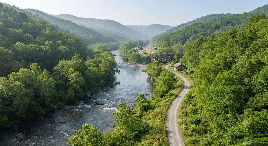
For those seeking an authentic immersion into West Virginia's natural beauty, the Greenbrier River Trail West Virginia delivers an unparalleled experience. Our team at Roam States has meticulously compiled this guide to help you navigate its 78 miles of breathtaking scenery, rich history, and abundant outdoor activities. From its gentle grades to its picturesque bridges and tunnels, this rail-trail is a true gem in the heart of the Allegheny Mountains, offering something for every type of adventurer.
Why Visit Greenbrier River Trail
The Greenbrier River Trail is more than just a path through the woods; it's a journey through the heart of West Virginia's wild and wonderful landscape. We recommend visiting for its unique blend of accessibility, natural splendor, and historical significance. As a former Chesapeake & Ohio (C&O) rail line, the trail follows the Greenbrier River for 78 miles, making it the longest trail of its kind in West Virginia. Its gentle one-percent grade makes it accessible for adventurers of all skill levels, from families with young children to seasoned long-distance cyclists.
The trail boasts 37 picturesque bridges and two historic tunnels: the 402-foot-long Droop Mountain Tunnel (built in 1900) and the 511-foot-long Sharps Tunnel (built in 1899). These features, combined with tranquil riverside views, abundant wildlife, and dense forests, create a truly immersive outdoor experience. It's no wonder that Backpacker Magazine rated the Greenbrier River Trail as one of the top 10 hiking trails in the U.S..
Beyond its natural allure, the Greenbrier River Trail offers a chance to disconnect. A significant portion of the trail lies within a National Radio Quiet Zone, meaning cell phone service is limited, allowing for a true escape into nature. This makes it an ideal destination for those looking to unplug and reconnect with the outdoors. Whether you're seeking a challenging bike ride, a peaceful hike, or a scenic horseback adventure, the Greenbrier River Trail provides a memorable backdrop for your West Virginia travels. You'll find that the Greenbrier River Trail West Virginia is truly worth visiting for its serene beauty and diverse recreational opportunities.
Who It's Best For
The Greenbrier River Trail is remarkably versatile, making it an excellent destination for a wide array of visitors. We find it particularly well-suited for:
- Families: The trail's gentle, mostly flat grade (a mellow one percent descent from Cass to Caldwell) means it's manageable for children on bikes or in strollers, offering a safe and enjoyable environment for family outings. Many access points offer convenient parking and amenities like picnic areas, making day trips easy to plan.
- Cyclists of All Levels: From casual riders to experienced touring cyclists, the Greenbrier River Trail caters to all. Its packed limestone fine surface is ideal for off-road bicycles, and the consistent grade allows for long distances without extreme exertion. Shuttle services are available for those who prefer to ride one-way.
- Hikers and Walkers: Whether you're looking for a short, scenic stroll or a multi-day backpacking adventure, the trail offers ample opportunities. The peaceful riverside setting and lush forest provide a serene atmosphere for walking and enjoying nature.
- Equestrians: Horseback riding is a popular activity on the Greenbrier River Trail, with several access points offering horse trailer parking. The wide, well-maintained path makes for a pleasant ride through picturesque landscapes.
- Nature Enthusiasts and Wildlife Watchers: The trail winds through remote areas of West Virginia, offering abundant opportunities to spot local wildlife and appreciate the diverse flora and fauna of the region.
- Campers: With numerous primitive campsites located directly along the trail, it's perfect for those who enjoy overnight trips under the stars.
Essentially, if you appreciate the outdoors, crave a break from the hustle and bustle, and enjoy activities like biking, hiking, or horseback riding in a scenic, accessible environment, the Greenbrier River Trail is an ideal choice.
Getting There & Parking
Navigating to the Greenbrier River Trail and finding suitable parking is straightforward, thanks to its numerous access points spread along its 78-mile length. The trail runs parallel to the Greenbrier River, extending from Caldwell in Greenbrier County to Cass Scenic Railroad State Park in Pocahontas County.
To get to Greenbrier River Trail, visitors typically choose an access point based on their desired starting location and planned activities. The southern terminus is near Caldwell, just north of U.S. Route 60. This access point offers parking, an information kiosk, drinking water, picnic tables, a bike repair station, and horse trailer parking. Another significant northern access point is at Cass Scenic Railroad State Park.
Throughout its length, there are many other access points with varying levels of amenities and parking availability. Some key access points in Greenbrier County include Hopper trailhead (Mile Marker 5.7), Anthony Road (Mile Marker 14.2) which offers horse trailer parking and river access, and Renick/Auto Road (Mile Marker 24.9) with horse trailer parking and a bicycle repair station. In Pocahontas County, access points like Seebert (near Mile Marker 45.77) and Buckeye (near Mile Marker 52.18) are also popular, though it's crucial to check for current closures due to ongoing bridge redecking projects.
Regarding Greenbrier River Trail parking, all trailheads along the Greenbrier River Trail generally include parking, though some offer more plentiful options than others. We recommend reviewing a detailed trail map, such as those available on the official Greenbrier River Trail website, to choose the best access point for your trip, especially if you plan to use a shuttle service or require specific amenities like horse trailer parking.
For those interested in exploring more of West Virginia, the trail is easily accessible from various parts of the state. Consider combining your Greenbrier River Trail adventure with a visit to nearby attractions such as Cass Scenic Railroad State Park, which serves as the trail's northern terminus. For a broader look at the state's offerings, our guide to Best Places in West Virginia provides further inspiration.
Top Things to Do
The Greenbrier River Trail offers a diverse range of activities, making it a fantastic destination for outdoor enthusiasts. Our team has identified the top things to do at Greenbrier River Trail, ensuring you make the most of your visit.
Greenbrier River Trail Hiking Trails
Hiking is one of the most popular activities on the Greenbrier River Trail. With 78 miles of former rail line, the trail provides a relatively flat and easy walking surface, making it enjoyable for all ages and fitness levels. The path is generally hard-packed, varying from rough to fine gravel. As you explore the Greenbrier River Trail hiking trails, you'll be treated to stunning riverside views, lush forests, and the chance to spot local wildlife. Backpacker Magazine even recognized it as one of the top 10 hiking trails in the U.S..
Key highlights for hikers include traversing the 37 bridges and two historic tunnels: Droop Mountain Tunnel and Sharps Tunnel. These features add a unique historical dimension to your trek. For those seeking longer adventures, the trail's numerous primitive campsites allow for multi-day hiking trips. Whether you're planning a short day hike or an extended backpacking journey, the Greenbrier River Trail hiking trails offer an unforgettable experience.
Biking
Cycling is arguably the quintessential activity on the Greenbrier River Trail. The smooth, gentle grade and well-maintained surface make it ideal for all types of bicycles, though off-road tires are recommended due to the packed limestone fines. You can rent bikes from local outfitters, many of whom also offer shuttle services to help you customize your ride length. Imagine pedaling through scenic valleys, crossing historic bridges, and emerging from cool, dark tunnels into sun-dappled woodlands. This is one of the premier things to do at Greenbrier River Trail.
Horseback Riding
Equestrians will find the Greenbrier River Trail to be a welcoming and beautiful destination. The wide trail accommodates horses, and several access points provide dedicated horse trailer parking. Riding along the river, surrounded by the tranquility of the forest, offers a unique perspective of this stunning landscape.
Camping
For those who wish to extend their adventure, Greenbrier River Trail camping is an excellent option. The trail features numerous primitive campsites that are free and operate on a first-come, first-served basis. Many of these sites offer basic amenities like picnic tables, fire rings, restrooms, and water. These primitive sites allow for an authentic wilderness experience right alongside the river. For more developed camping options, nearby state parks and private campgrounds offer additional facilities. We'll delve deeper into Greenbrier River Trail camping in the "Where to Stay Nearby" section.
Fishing and Water Activities
The Greenbrier River itself is a major draw. Following the longest free-flowing river in the East, the trail offers plentiful fishing opportunities. Many sections of the river are easily accessible from the trail, providing ideal spots for anglers. Additionally, some local outfitters offer tubing, kayaking, and canoeing trips on the Greenbrier River, with options for various skill levels, including Class I through Class III whitewater sections. Swimming holes are also popular along the river, especially near access points like Anthony Creek.
Wildlife Viewing and Photography
The remote nature of the Greenbrier River Trail means abundant opportunities for wildlife viewing. Keep an eye out for deer, black bears, various bird species, and other forest creatures. The scenic beauty, from the river itself to the dense rhododendron thickets and sweeping vistas, also makes it a fantastic location for nature photography.
When considering things to do at Greenbrier River Trail, remember to check for current trail conditions and closures, especially regarding the ongoing bridge redecking project, to ensure a smooth and enjoyable visit.
Best Time to Visit
Choosing the best time to visit the Greenbrier River Trail largely depends on your preferred activities and tolerance for crowds and weather conditions. Our team recommends considering the following seasons:
- Spring (April to May): This is an excellent time for hiking and biking as the weather is generally mild, and the landscape bursts with new life. Wildflowers are in bloom, and the river flows robustly. However, spring can also bring rain, so be prepared for potentially muddy sections of the trail.
- Summer (June to August): Summer offers warm weather, perfect for combining trail activities with swimming or tubing in the Greenbrier River. The foliage is lush and green. Be aware that this is a popular time, so expect more visitors, especially on weekends. It's also important to stay hydrated and be mindful of potential afternoon thunderstorms.
- Fall (September to October): Many consider autumn the absolute best time to visit the Greenbrier River Trail. The cooler temperatures are ideal for long hikes and bike rides, and the Allegheny Mountains transform into a spectacular display of fall colors. This vibrant scenery draws many visitors, so expect higher popularity, particularly during peak foliage weeks.
- Winter (November to March): While less popular for traditional hiking and biking due to colder temperatures and potential snow or ice, the trail can offer a serene, solitary experience for those prepared for winter conditions. Cross-country skiing and snowshoeing are possible after significant snowfall. However, some services and amenities in nearby towns may have reduced hours.
Regardless of the season, we always recommend checking the official Greenbrier River Trail website or West Virginia State Parks for current trail conditions, weather forecasts, and any specific alerts or closures before your visit. For example, a significant bridge redecking project is underway from early 2026 through November 2027, which may affect certain sections of the trail at various times.
Where to Stay Nearby
When planning your trip to the Greenbrier River Trail, you'll find a range of lodging options to suit every preference, from rustic Greenbrier River Trail camping to comfortable cabins and charming inns in nearby towns. Our team has compiled some of the best places to stay to enhance your trail experience.
Greenbrier River Trail Camping
For an immersive outdoor experience, Greenbrier River Trail camping is an ideal choice. The trail itself features numerous primitive campsites that are free and available on a first-come, first-served basis. These sites often include basic amenities like picnic tables, fire rings, and access to restrooms and water. This allows you to truly connect with nature and wake up right alongside the river.
For more amenities, Greenbrierriver Campground, located near Alderson, offers RV and tent sites, as well as fully-equipped cabins. This campground is open from April through October and provides facilities such as 30 and 50 amp service for RVs, water, sewer, cable TV, WiFi, bathhouses, and laundry facilities. They also offer river trips directly from the campground.
Additionally, several state parks and forests along the Greenbrier River Trail offer overnight accommodations, including Greenbrier State Forest, Watoga State Park, Seneca State Forest, and Cass Scenic Railroad State Park. These typically offer a mix of cabins and more developed campsites that may require reservations.
Hotels and Inns in Nearby Towns
For those preferring more traditional lodging, several charming towns near the Greenbrier River Trail offer hotels, motels, and bed-and-breakfasts:
- Lewisburg: Located near the southern terminus of the trail (Caldwell), Lewisburg is a historic town known for its vibrant arts scene, boutiques, and excellent dining options. It offers a variety of accommodations, from cozy B&Bs to modern hotels.
- Marlinton: Situated roughly in the middle of the trail, Marlinton is a convenient base for exploring different sections. It's a smaller town with local lodging options and services catering to trail users.
- Cass: Home to Cass Scenic Railroad State Park, the northern terminus of the trail, Cass offers unique lodging in historic company houses and a general store. It's perfect for those who want to combine their trail adventure with a step back in time.
- White Sulphur Springs: Home to the iconic The Greenbrier Resort, this town offers luxury accommodations and is a short drive from the trail's southern end.
When selecting your lodging, consider your desired access points for the Greenbrier River Trail and the type of experience you're seeking. Booking in advance, especially during peak seasons like fall, is always a good idea.
Sample 2-Day Itinerary
To help you make the most of your visit to the Greenbrier River Trail, our team has crafted a sample 2-day itinerary. This plan focuses on experiencing the diverse offerings of the Greenbrier River Trail West Virginia, balancing active exploration with relaxation.
Day 1: Southern Charm & Scenic Cycling
- Morning (9:00 AM - 1:00 PM): Southern Terminus Exploration & Bike Ride
- Begin your adventure at the southern terminus of the Greenbrier River Trail near Caldwell (Mile Marker 3), easily accessible from Lewisburg. This access point offers ample parking, restrooms, and an information kiosk.
- Rent bicycles from a local outfitter in Lewisburg or bring your own.
- Cycle northward from Caldwell. The trail here is particularly scenic, passing through lush forests and alongside the gentle flow of the Greenbrier River. You'll cross several charming bridges.
- We recommend a ride to the Anthony Road access point (Mile Marker 14.2) or even further to Renick (Mile Marker 24.9), depending on your energy and time. This section is known for its serene river views and potential swimming spots.
- Lunch (1:00 PM - 2:00 PM): Picnic by the River or Local Eatery
- Enjoy a packed lunch at one of the trailside picnic areas, or head into Lewisburg for a meal at a local restaurant.
- Afternoon (2:00 PM - 5:00 PM): Lewisburg Exploration & Relaxation
- Return to Lewisburg and spend the afternoon exploring this historic town. Browse the unique shops, visit art galleries, or simply enjoy the charming architecture.
- Consider a visit to The Greenbrier Resort in nearby White Sulphur Springs for a glimpse of its grandeur, or simply relax at your accommodation.
- Evening: Dinner in Lewisburg
- Savor a delicious dinner in Lewisburg, known for its diverse culinary scene.
Day 2: Northern Wilderness & Historic Rails
- Morning (9:00 AM - 1:00 PM): Cass Scenic Railroad & Trail Hiking
- Drive north to Cass Scenic Railroad State Park, the northern terminus of the Greenbrier River Trail.
- Take a ride on the historic Cass Scenic Railroad, an unforgettable experience that transports you back to the logging era.
- After your train ride, explore the northernmost sections of the Greenbrier River Trail on foot. Hike a few miles south from Cass, enjoying the more rugged and remote feel of this part of the trail. This section offers glimpses of the trail's two tunnels, Droop Mountain Tunnel and Sharps Tunnel, though check for current closures due to bridge work.
- Lunch (1:00 PM - 2:00 PM): Trailside or Marlinton
- Pack a lunch to enjoy on the trail or head to Marlinton, a trail town with a few local eateries.
- Afternoon (2:00 PM - 5:00 PM): Greenbrier River Trail Camping Experience or Further Exploration
- If you're interested in Greenbrier River Trail camping, set up camp at one of the primitive sites near Marlinton or further south.
- Alternatively, if camping isn't your plan, continue exploring more of the trail by bike or on foot from a different access point, perhaps near Watoga State Park. You could also visit other nearby attractions, such as Blackwater Falls State Park, though it's a bit further afield.
- Evening: Stargazing & Reflection
- Enjoy a quiet evening, perhaps around a campfire if camping, and take advantage of the dark skies for stargazing. Reflect on the natural beauty and history you've experienced on the Greenbrier River Trail.
This itinerary is flexible and can be adjusted based on your interests and the current trail conditions. Remember to always check for the latest information on closures and services before heading out. For more West Virginia adventures, consider our guides to destinations like the Beckley Exhibition Coal Mine or Blennerhassett Island Park.
Last updated: 2026-07-13 by the Roam States team.