Big Sur & PCH Travel Guide — California
Our team at Roam States has meticulously crafted this Big Sur & PCH California travel guide to equip you with everything needed for an unforgettable journey along this iconic stretch of the Central Coast. We cut through the noise to deliver confident, specific, and actionable advice, ensuring your trip through one of America's most scenic wonders is nothing short of spectacular. This guide focuses on helping you navigate the breathtaking landscapes, discover hidden gems, and experience the unique allure of Big Sur and the Pacific Coast Highway.
Why Visit Big Sur & PCH
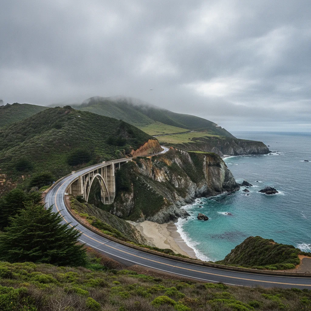
Big Sur and the Pacific Coast Highway (PCH) offer an unparalleled blend of dramatic coastal cliffs, ancient redwood forests, and the vast expanse of the Pacific Ocean. This isn't just a drive; it's an immersive experience where every turn reveals a postcard-perfect vista. We believe it's a destination that speaks to the soul, inviting travelers to slow down, breathe in the fresh ocean air, and witness nature's grandeur firsthand. The region is a testament to California's wild beauty, a place where rugged terrain meets serene seascapes, making it a prime example of the state's hidden gems and scenic wonders. From the iconic Bixby Bridge to the serene coves, the allure of Big Sur & PCH California is undeniable for those seeking adventure and tranquility.
Who It's Best For
Big Sur & PCH is ideal for a diverse range of travelers. Road trip enthusiasts will revel in the legendary Highway 1, a route celebrated globally for its stunning views. Nature lovers and photographers will find endless inspiration in the dramatic coastline, towering redwoods, and abundant wildlife. Hikers have a wealth of trails to explore, from gentle strolls to challenging ascents. Couples seeking a romantic getaway will appreciate the secluded beauty and breathtaking sunsets. While primarily known for its scenic drive, the area also offers experiences for families, particularly those with older children who can appreciate the natural beauty and participate in moderate outdoor activities. It’s less suited for those seeking bustling nightlife or extensive shopping, as the focus here is squarely on the natural environment.
Getting There & Parking
Accessing Big Sur & PCH primarily involves driving California's iconic Highway 1. As of January 14, 2026, Highway 1 is fully reopened, allowing unimpeded travel between Monterey and San Luis Obispo, following a three-year closure for repairs. However, travelers should always check Caltrans' website for the latest road conditions, as this curvy and moody highway is prone to lane restrictions and closures due to weather or ongoing maintenance. For instance, one-way traffic controls and delays can occur in various segments for slide work, pavement repair, or utility work, as observed in June 2026. Caltrans had previously announced that Highway 1 at Regent's Slide was expected to reopen to through traffic by the end of March 2026.
When considering how to get to Big Sur & PCH, most visitors drive from either the north (via Monterey and Carmel) or the south (via San Luis Obispo and Cambria). The nearest major airports are in San Jose (SJC) and San Francisco (SFO) to the north, and San Luis Obispo (SBP) to the south. From these hubs, a rental car is essential for exploring the region.
Parking along Big Sur & PCH can be challenging, especially at popular viewpoints and trailheads. Many state parks along the route, such as Pfeiffer Big Sur State Park, Julia Pfeiffer Burns State Park, and Point Lobos State Natural Reserve, charge a day-use vehicle fee, typically $10. It's advisable to carry cash, as some kiosks are self-service when no attendant is present.
A significant development for parking concerns the iconic Bixby Bridge. Monterey County supervisors approved a 12-month pilot no-parking program on both sides of Highway 1 near Bixby Bridge, effective as soon as signs are permitted and placed. This ban prohibits parking approximately 900 feet north and 700 feet south of the bridge, and also on portions of the nearby Old Coast Road. This measure aims to address public safety concerns, traffic congestion, and illegal roadside parking that increased significantly after Highway 1's full reopening. We recommend arriving early to popular spots or visiting during off-peak times to secure parking.
Top Things to Do
The array of things to do at Big Sur & PCH is as diverse as its landscape. Our team has curated a list of essential experiences for your journey:
- Drive Highway 1: The very act of traversing Highway 1 is an attraction in itself. Take your time, pull over at designated turnouts, and soak in the panoramic ocean views.
- Visit Bixby Bridge: This architectural marvel is one of the most photographed bridges in California. While parking directly at the bridge is now restricted, there are still opportunities to view it from safe, designated areas further away.
- Explore State Parks:
- Pfeiffer Big Sur State Park: Often called a "mini Yosemite," this park offers extensive hiking trails through redwood groves, opportunities for swimming in the Big Sur River, and popular campgrounds. The park is open for day use from 8 AM to sunset, with a vehicle day-use fee of $10.
- Julia Pfeiffer Burns State Park: Home to the famous McWay Falls, where an 80-foot waterfall cascades onto a pristine beach (which is closed to public access). The Waterfall Overlook Trail to view McWay Falls is currently closed for a long-term retaining wall repair project expected to continue into 2026, limiting parking within the park. Day-use entry is $10 per vehicle.
- Point Lobos State Natural Reserve: Known as the "crown jewel of the California State Park System," Point Lobos offers stunning coves, rich marine habitats, and excellent opportunities for hiking, photography, and wildlife viewing (sea lions, sea otters, and migrating whales). The reserve is open from 8 AM to 7 PM, with last entry at 6:30 PM, and charges a $10 vehicle day-use fee. Vehicles over 21 feet long are generally not allowed to drive or park within the reserve, especially during peak times.
- Garrapata State Park: This northernmost Big Sur state park offers two miles of coastline, a dramatic beach, and trails that wind through chaparral and redwood forests. It's open from 8 AM to sunset and notably does not have an entrance fee. Dogs are allowed on the beach at Gate 19 and trails leading to it, but not in other areas. The Rocky Ridge Trail is closed due to hazardous conditions, but the Soberanes Canyon Trail is open.
- Hiking: Beyond the state parks, numerous trails offer varying levels of difficulty. Some of the best things to do in Central Coast involve lacing up your boots and exploring the diverse ecosystems.
- Wildlife Viewing: Keep an eye out for California condors soaring overhead, sea otters playing in the kelp beds, and seals basking on the rocks. During winter migrations, whales can be spotted from various viewpoints, especially at Garrapata State Park.
- Photography: With dramatic cliffs, crashing waves, and unique light, Big Sur is a photographer's dream.
For those interested in things to do at Big Sur & PCH beyond the main attractions, consider a visit to the historic Hearst Castle, located a bit further south, or explore the charming towns of Carmel-by-the-Sea and Monterey to the north.
Best Time to Visit
The best time to visit Big Sur & PCH is generally during the spring (April to May) and fall (September to November). During these seasons, the weather is typically mild, with fewer crowds than the peak summer months. Spring brings vibrant wildflowers, while fall offers clear skies and comfortable temperatures. Summer (June to August) is popular for its warm weather and longer daylight hours, but it also sees the highest number of visitors, leading to more crowded viewpoints and potentially competitive parking situations. Mornings often start with coastal fog that usually burns off by midday in summer. Winter (December to March) offers a quieter experience with dramatic stormy seas, but also brings the highest risk of road closures due to landslides and heavy rains. Highway 1 is particularly vulnerable to landslides and shifting ground, operating on a cycle of closure, repair, and reopening.
Where to Stay Nearby
While Big Sur itself offers a limited number of unique and often high-end accommodations, many visitors opt to stay in nearby towns and explore the Big Sur & PCH California region as day trips. Our team recommends considering:
- Carmel-by-the-Sea: To the north, Carmel offers a charming village atmosphere with boutique hotels, art galleries, and fine dining. It's a convenient base for exploring the northern reaches of Big Sur and attractions like 17-Mile Drive and Monterey Bay Aquarium.
- Monterey: A larger city just north of Carmel, Monterey provides a wider range of accommodation options, from budget-friendly motels to luxury resorts. It's an excellent choice for families and offers easy access to the Monterey Bay National Marine Sanctuary.
- Cambria/San Simeon: To the south, these towns offer more affordable lodging and serve as a good starting point for those approaching Big Sur from Southern California. They are also close to Hearst Castle.
- Camping: For a truly immersive experience, camping along Big Sur & PCH is an option, though reservations are highly competitive. Pfeiffer Big Sur State Park and Julia Pfeiffer Burns State Park offer campsites, with reservations opening six months in advance and filling quickly. Pfeiffer Big Sur has standard sites for $50/night and premium riverfront sites for $60/night, plus a cabin option for $75/night. Julia Pfeiffer Burns State Park also has environmental campsites for $30 per night, which require parking within the park and hiking to the assigned spot. Andrew Molera State Park also offers walk-in tent camping. Be aware that illegal camping is actively discouraged in Monterey County.
Sample 2-Day Itinerary
Here’s a sample 2-day itinerary for experiencing the best of Big Sur & PCH California:
Day 1: Northern Big Sur Highlights
- Morning: Start your day early from Carmel or Monterey. Drive south on Highway 1, making your first significant stop at Point Lobos State Natural Reserve. Spend 2-3 hours hiking the scenic trails, spotting wildlife, and taking in the stunning coastal views. Remember the $10 vehicle day-use fee and plan to arrive early for parking.
- Late Morning: Continue south to Garrapata State Park. Enjoy a leisurely walk along the beach at Gate 19 or explore the Soberanes Canyon Trail. There's no entrance fee here, making it a great stop to stretch your legs.
- Lunch: Grab a casual bite at a cafe or deli in the Big Sur Village area.
- Afternoon: Drive to the iconic Bixby Bridge for a photo opportunity. Be mindful of the new parking restrictions, which prohibit parking directly at the bridge. Continue to Pfeiffer Big Sur State Park. Hike among the redwoods, perhaps taking the scenic Pfeiffer Falls Trail (check for current trail conditions).
- Evening: Check into your accommodation in Big Sur, or head back north to Carmel or Monterey. Enjoy dinner with a view if possible.
Day 2: Southern Big Sur & Beyond
- Morning: Head south to Julia Pfeiffer Burns State Park. Despite the closure of the McWay Falls Overlook Trail for repairs into 2026, you can still view the falls from a small viewing area on the side of Highway 1. The Ewoldsen Trail remains open for a redwood forest hike.
- Late Morning: Continue your drive south, enjoying the winding roads and dramatic cliffs. Consider a stop at Nepenthe for its famous views (and perhaps a coffee or snack).
- Lunch: Enjoy lunch at a restaurant further south along Highway 1, or pack a picnic to enjoy at a scenic turnout.
- Afternoon: Depending on your interests and onward travel plans, you could visit the historic Hearst Castle (reservations highly recommended), or explore one of the lesser-known beaches like Sand Dollar Beach.
- Evening: Begin your journey back north or continue south towards your next destination.
Our team emphasizes that this Big Sur & PCH itinerary is flexible. Road conditions, especially on Highway 1, can change rapidly due to weather or ongoing maintenance. Always check the latest updates before and during your trip. We also recommend making reservations for dining and lodging well in advance, especially during peak season.
Last updated: 2026-07-12 by the Roam States team.